|
Geological Tour
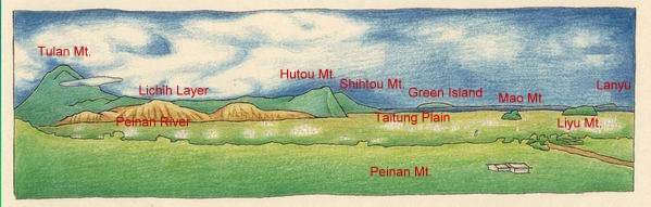
At The Lookout of the park, the formation of the land, the prosperity and adversity of civilization, the large plates resulted from millions of years of geological are within a glimpse. We are standing on the convergent belt of the ocean and land plates. The Costal Range on the east side is the former Philippine Sea plate. The northeast part of Lyusong Island Arc reaches south to Green Island and Lanyu. The Central Mountains on the west side belonged to the basement system of the former Eurasia Plate and the bulged accrual prism sediments. Peinan River wanders along the Hua-tung longitude rift valley on the convergent belt of the plates, and rushes into the sea by days and nights. Tulan Mt., Hutou Mt., Shihtou Mt., Mao Mt., Liyu Mt., settled on distant sides, and the silence between them has been in existence since time immemorial. These seemingly everlasting scenes are in fact just one moment of the universe that stops in a trice.
|